
Walk & Roll 794: Final Route Findings and Community Visioning
- raphie093
- Jun 2
- 2 min read

Rethink 794 concluded our Walk & Roll series with our final route looping around the Clybourn Bridge closure. The audit took place on Wednesday, May 27th near the end of peak rush hour. To view a summary of observations and route map, you can find a brief report of the walk-roll audit below:
On the route, participants noted fragmented and incomplete pedestrian and bicycle infrastructure, especially near the freeway ramps west of the river. The observation reinforces a consistent finding from previous walk-audits: the movement of vehicles is prioritized, often at the cost of continuous access for those walking and biking.


Left: View of I-43 N on-ramp and elevated I-794 structure from NE corner of Clybourn & Plankinton Ave.
Right: View of Mitchell Building from SW corner of Water St. & Wisconsin Ave.
At the same time, the audit highlighted strong contrasts in experience across the corridor. Areas near Water Street and the river front felt more active and comfortable, and supported by transit access and development, including publicly accessible spaces. Conditions shifted quickly within just a few steps, into less connected environments. Participants also shared concerns about the persistent freeway noise, which extends into the surrounding blocks and impacts street-level comfort.
Putting together a creative vision


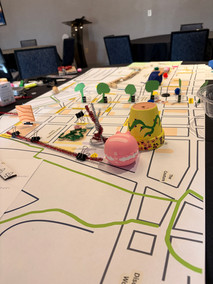


Following the walk-roll audit, participants engaged in a creative visioning exercise to imagine future possibilities for the corridor, beyond the existing constraints. Though participants were initially uncertain about this more “play-like” approach, the resulting visions (listed at left; pictured above) reflected detailed and creative ideas for what they would like to see in the I-794 corridor and surrounding area. The themes included more intuitive and cohesive transportation connections for all modes, particularly between Downtown, the Third Ward, Walker’s Point, and even the Menomonee Valley. Participants also depicted unique ideas for improved pedestrian safety and neighborhood development, enhanced green
infrastructure, and more cohesive public realm.
As WisDOT transitions to the Environmental Impact Assessment phase of the Lake Interchange study, it will be important to elevate and add to these community identified priorities and clarify the range of outcomes across the alternatives in the study, in terms of connection, safety, and the quality of public amenities.
There are still immediate steps you can take:
WisDOT’s Lake Interchange study page remains open for public comment. Submit comments to their public comment form through June 5.
Call and email your alderperson and county board member and let them know why you want a removed or reconfigured I-794.
Whether as an attendee at our events or in your own time, we invite all to walk & roll through the I-794 corridor at street level. First-hand experiences often provide new perspective.


